| 4. |  James Lemuel "Lem" Palmer was born on 5 Jul 1867 in Stokes County, North Carolina (son of Unknown (not married) and Elizabeth Jane Collins); died on 21 Feb 1940 in Raven, Tazewell County, Virginia; was buried on 24 Feb 1940 in Palmer Cemetery, Road Ridge, Raven, Tazewell County, Virginia. James Lemuel "Lem" Palmer was born on 5 Jul 1867 in Stokes County, North Carolina (son of Unknown (not married) and Elizabeth Jane Collins); died on 21 Feb 1940 in Raven, Tazewell County, Virginia; was buried on 24 Feb 1940 in Palmer Cemetery, Road Ridge, Raven, Tazewell County, Virginia. Other Events:
- Census: 1900, Gladeville, Wise, Virginia, USA
- Census 1910: 1910, Maiden Springs District, Tazewell, Virginia, USA
- Deed: 13 Jun 1910, Coal Creek, Tazewell County, Virginia; Deed between J.L. Palmer and Susan F. Palmer and P.O. Palmer, Mary Belle Palmer
- Deed: 15 Aug 1912, Tazewell County, Virginia; Susan F. Palmer and Powell Palmer Deed
- Deed : 2 Sep 1912, Tazewell County, Virginia; A.L & Cora Cacy to J.L & Susan Palmer for $500 a tract of land containing 20 acres on the waters of Mill Creek and Coal Creek tributaries of Clinch River in Tazewell County. Deed book 72 page 504
- Deed: 4 Jun 1917, Tazewell County, Virginia; J.L. Palmer & Susan Palmer his wife and Sylvester Mallory Deed.
- Census 1920: 1920, Maiden Spring, Tazewell, Virginia, USA
- Census 1930: 1930, Maiden Spring, Tazewell, Virginia, USA; Living with 2nd wife Susan and daughter Elsie. Owns farm. Does not own a Radio Set. Able to read/write. Miner, currently employed at age 62
- Newspaper: 23 Jan 1938, Raven, Tazewell County, Virginia; J. L. Palmer is seriously ill at his home on Road Ridge.
Notes:
Presley is not James Father - although on all documentation of James - Presley is stated as father. Presley died in the war - James was born in 1867, a few years after Presley died. Since Elizabeth never remarried - the father of James remains a mystery.
Birth:
Presley Palmer was not the father of James. Presley died in the Civil War, James was born in 1867. He went by Palmer. No way to know who his real father was.
Deed:
This deed made this 13th day of June, in the year 1910, between J.L. Palmer and Susan F. Palmer, of Tazewell County, Virginia, parties of the first part and P.O. Palmer, Mary Belle Palmer, of Tazewell County, Virginia parties of the second part.
Whereas, by deed dated the 18th day of June, 1906, John Ball and others conveyed to the said J.L. Palmer and P.O. Palmer jointly, a certain piece or parcel of land, situated in Tazewell County, Virginia, lying and being on the waters of Coal Creek, on the East side of the Road Ridge Road, containing 12-210 acres, the metes and bounds of said land being fully mentioned in said deed, which deed is recorded in the office of the Clerk of the Circuit Court of Tazewell County, Virginia, in Deed Book 59 Page 439 etc. and for a more definite description of the said land, reference is hereby made to said deed and it was understood that P.O. Palmer was to have 8 acres out of said boundary of land and the said J.L Palmer was to have the remainder of same, and the said J.L. Palmer and P.O. Palmer have this day partitioned and divided the said tract of land, as follows, therefore, this deed. Witnesseth: that in consideration of the sum of money paid into the purchase of said tract of land, by the said P.O. Palmer, the following portion of said land as his part thereof.
Beginning at a stake in line of George Ball, bearing north 59.15 east 55 feet from dogwood, corner between George Ball and the land this day conveyed to J.L. Palmer, thence N. 20 15 west, 176.1 feet to a stake in a small ravine, thence N 2 20 East ___ to a stake, on the side of a hill, thence N 86 40 West to a point in the center of the road ridge road, corner to Charles Cordill, and with the said road, N. 3 0 East 306.2 feet to a stake, corner of School House lot, thence S 89 0 East 127 feet to a double maple, thence N. 1 15 East 290.6 feet to a chestnut, corner of John Ball, thence S. 89 ) East 312.8 feet to a chestnut on the bank of a small branch, thence with the branch, S 15.45 East 60 feet, S. 21.30 East 70 feet, S. 8 E 190 feet, S 15 30 East 200 feet, S 25.30 East 300 feet to a beech on the west bank of the branch, thence S. 59.15 W. 383.7 feet to the beginning, containing 8 acres, more or less. And in consideration of the sum of money paid into the purchase of said tract of land, by the said J.L. Palmer, the said parties of the second part do bargain and convey unto the said J.L. Palmer the remainder of said tract of land, as his portion thereof, which portion is bounded as follows: Beginning at a white oak, corner of George Ball, and with his line N. 44 E 417 feet to a double dogwood on a spur, N 59 15 E 55 feet to a stake, corner of the land this day conveyed to the said P.O. Palmer, thence with three lines of same, N 20.15 West 176.1 feet to a stake in a small ravine, thence N. 2 10 East to a stake, on the side of a hill, thence N. 86 40 west to a point in the center of road ridge road, corner to Charles Cordill, thence leaving said P.O. Palmer's land and with the said road, S 4 W 83.7 feet to a stake in said road, S. 06 E 96 feet to a stake in said road, S 19.45 E 297.5 feet to the beginning, containing 42 acres, more or less. The said parties hereto covenant with each other that the said P.O. Palmer shall hold the land this day deed __ to him free of the claims of the said parties of the first part and that and that the said J.L. Palmer shall hold the land this day conveyed to him, free from the claims of the said parties of the second part. Witness the following signatures and seals: J.L. Palmer (seal) P.O. Palmer (seal) Susan P. Palmer (seal) Mary B. Palmer (seal)
Deed:
This contract made and entered into this fifteenth day of August, 1912, by and between Susan F. Palmer, party of the first part and P.O. Palmer, party of the second part.
WITNESSETH that for and in consideration of the sum of one hundred ten dollars ($110.00), cash in hand paid, receipt of which is hereby acknowledged, the party of the first part bargains, sells and conveys unto the party of the second part, his heirs and assigns forever, a certain parcel of land situated on Coal Creek, in Tazewell County, Virginia and described as follows in survey made by T. P. Morgan, August 10, 1910.
Beginning at a stake in the center of Coal Creek, a corner of the R. B. Griffith land, and with center of creek S 30' W. 30' S. 17' 20 W 194' to a stake; thence leaving creek N. 80' W 205' to a stake in a line of R. B. Griffith and with it reversed N. 53' E. 308' to the beginning, containing 51/100 acres.Said land contains a swelling and other improvements, all of which are concluded in this conveyance. This being the same parcel of land as conveyed by deed to said party of the first part by A. L. Cacy, and this deed is subject to such reservations as made in said deed of A. L. Cacy as respects the rights of the owners of the coal underlying said land.Witness the following signatures and seals this the date first above written.Susan F. Palmer (Seal) J. L. Palmer (Seal)Personally appeared before me L. D Kinksbury, a Justice of the Peace for Tazewell County, in my county aforesaid, Susan F. Palmer and J. L. Palmer, who being duly sworn declared that the signature appearing above is her signature and that the foregoing deed was read and understood by her. Witness my hand this the 26 day of October 1912.L. D. Kinksbury, Justice of the Peace for Tazewell County.
James married Margaret Liddia Lawson on 22 Apr 1886 in Patrick, Virginia, USA. Margaret (daughter of Tucker K. Lawson Jr. and Lucinda R. Hill) was born on 18 Oct 1866 in Stokes County, North Carolina; died on 11 May 1908 in Tazewell County, Virginia; was buried on 13 May 1908 in Smith Family Cemetery, Road Ridge, Raven, Tazewell Co, Va. [Group Sheet] [Family Chart]
|

 Walter Robert Palmer was born on 23 Sep 1900 in Wise County, Virginia (son of James Lemuel "Lem" Palmer and Margaret Liddia Lawson); died on 26 Jul 1985 in Richlands, Tazewell County, Virginia; was buried in Clinch Valley Memorial Cemetery, Richlands, Tazewell County, Virginia, USA.
  Mable Virginia Dye was born on 11 October 1900 in Virginia, United States; died on 25 May 1984 in Tazewell County, Virginia.
  Margaret Liddia Lawson was born on 18 Oct 1866 in Stokes County, North Carolina (daughter of Tucker K. Lawson Jr. and Lucinda R. Hill); died on 11 May 1908 in Tazewell County, Virginia; was buried on 13 May 1908 in Smith Family Cemetery, Road Ridge, Raven, Tazewell Co, Va.
 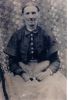 Elizabeth Jane Collins was born on 1 October 1831 in Patrick, Virginia, USA (daughter of Leaton Collins and Sarah "Sallie" N. Tucker); died on 1 February 1925 in Big Creek, Stokes, North Carolina.
 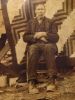 Tucker K. Lawson Jr. was born on 1 Sep 1846 in Stokes County, North Carolina (son of Tucker Lawson Sr. and Elizabeth "Betty" Lankford); died on 5 Sep 1928 in Tazewell County, Virginia; was buried on 7 Sep 1924 in Smith Cemetery, Red Root Ridge, Tazewell County, Virginia.
  Lucinda R. Hill was born on 13 Sep 1848 in Stokes County, North Carolina (daughter of Thomas Hill and Louisa Lankford); died on 19 Feb 1929 in Tazewell County, Virginia.


